|
Exploring Land Use with Landsat |
||||||||
|
|||||||||
 |

Mathematics Skill or Topic Area:
Fraction Operations
Next Gen Science Standards: ESS2: Earths Systems; ETS2: Links Among Engineering, Technology, Science, and Society; LS2: Ecosystems: Interactions, Energy, and Dynamics
Common Core ELA for Science: RST.6-8.2. Determine the central ideas or conclusions of a text; provide an accurate summary of the text distinct from prior knowledge or opinions. RST.6-8.8. Distinguish among facts, reasoned judgment based on research findings, and speculation in a text. RST.6-8.9. Compare and contrast the information gained from experiments, simulations, video, or multimedia sources with that gained from reading a text on the same topic.
Common Core Math Standard: CC.6.NS.1: Interpret and compute quotients of fractions, and solve word problems involving division of fractions by fractions.

Video Engagement: NASA and the Chesapeake Bay Learn how NASA uses Earth observing satellites to monitor conditions in the Chesapeake Bay over time. Information about pollution, eutrophication, land cover and watershed runoff helps water managers enact policies to improve the health of the Bay (8 minutes). View Program
|
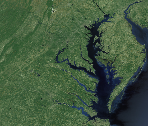
Engage your students with a press release: Landsat's Role in Chesapeake Bay Management
Information collected from 438 miles above Earth by the Landsat satellites has brought Chesapeake Bay scientists one
step closer to better controlling pollution levels throughout the watershed. This is because Landsat give earth scientists a birds-eye
view of the 168,000 square-kilometer watershed in such detail that they can at last decipher human land use and land cover patterns.
Land cover data is critical for decision-making at the Chesapeake Bay Program, CBP GIS team leader, John Wolf says.
To take on the enormous task of improving water quality over such a vast area, Bay managers use mathematical models to
analyze large amounts of information. These mlodels can then be used to predict the most effective methods for lessening watershed pollution.
The nature
of the watersheds landscapethe amount of paved or impervious surfaces, the proportions of cropland and rangeland, forested regions,
marshland and the likeis a key input for these forecasting models. Landsat land cover data are fed into the Chesapeake Bay
Programs Watershed Model to predict where nutrient loads can be expected and where managers should take action.
Thanks to a Landsat studies of the many different pollution contributions, each part of the Chesapeake watershed now has
individualized pollution reduction targets. Through assessing the magnitude and relative contribution of upland pollution sources,
the Bay Program partners were able to allocate nutrient and sediment load reduction targets to sub-regions throughout the 64,000 square-mile
Chesapeake Bay watershed, Peter Claggett, a USGS Research Geographer and Land Data Managers for the CBP, explains.
Press release date line - April 22, 2008 Press release
location: [
Click Here ] |
|

Explore
math connections with SpaceMath@NASA
Problem I -
Estimating Land Use from Space using Landsat -
Across the entire Chesapeake Watershed, 2/7 of the land area is forested, 1/2 is wetlands,
and 1/10 is cultivated. How much of the land area is in the fourth category of 'developed'? [Answer: Add up the
fractions to get (1/2+2/7) = 11/14 ,add this to 1/10 to get 31/35, then subtract from 35/35 to get the
answer that 4/35 of the land area is developed.]
Problem II -
Land Use in the Cub Run Watershed in Northern Virginia -
Students explore how development and de-forestation alter the way in which land is used over time.
They investigate the Cub Run Watershed in Northern Virginia using data spanning 1990 - 2000. Students use fractions to estimate changes in
forestation during this 10-year period. [Open
PDF]
Explain
your thinking: Write
your own problem - Using information
found in the Math Connection problems, the press release or the video
program, create your own math problem. Explain why you set the problem up this
way, and how you might find its answer.
Evaluate
your understanding: Challenge Problem
-
If the forested area in the Chesapeake Watershed began with 94,000 square kilometers in 1990
and decreased by 1/90 every 10 years, how long will it take before the amount of forested area has been reduced to 1/2 of its original
area in 1990?
Answer: We need to reduce the current
value by 1/2 so we need to find how many times 1/90 goes into 1/2. The answer is 45 times
since 45 x (1/90) = 1/2. Then we need 45 decades or 450 years to reduce the forested area by 1/2.

NASA / JPL
3-D Solar System
Extend your new knowledge - Visit our own Earth using the EOSS simulator and explore Landsat's orbit. [ Open PDF ]